

17 Sep Why Drone Photography Is a Must-Have for Real Estate Listings
| Drone photography is no longer a luxury add-on. Drones for real estate photography show buyers a property’s lot size, layout, and surroundings in a way ground-level photos physically cannot, and for the larger or waterfront homes common across Westchester and Fairfield County, that context can be the deciding factor in getting a showing. Aerial coverage means better-informed buyers and faster decisions, especially on large-lot, waterfront, or privacy-focused properties where the setting is the whole appeal. |
A listing that lingers gets expensive for the seller. The longer it sits, the more a price cut starts to feel unavoidable, and a home that looked fresh at launch soon reads as the one buyers keep skipping past.
Interior photos can’t help here. They won’t show a buyer how much land comes with the house, where the guest house sits, or how near the water really is. Ask someone to size up a two-acre estate from eight shots of the kitchen and living room, and they are working half-blind.
For many buyers, the drone shot is what stops the scroll and sells the setting before they have read a single word. Get it right, and you reach buyers your competition doesn’t. Here’s how to make sure your drone photos for real estate do the job, and why you need them in the first place.
Key Takeaways
- Drones for real estate photography capture lot size, layout, and boundaries that ground-level photos simply can’t show.
- Commercial drone operation in the U.S. legally requires FAA Part 107 certification, so always confirm your operator holds it.
- The real estate drone photography benefits land hardest on properties over roughly half an acre, waterfront homes, and anything with distinctive outdoor features.
- Twilight drone shots are a premium upsell. Pairing them with twilight real estate photography makes luxury listings stand out after dark.
What Aerial Photography Actually Shows Buyers
Using drones for real estate settles the questions a buyer actually cares about before they’ll give up a Saturday to visit. How big is the lot? What’s next door? Does the place hang together as one property, or does it feel like bits stitched onto a small house? Ground-level photography leaves all of that to the imagination, but drone photography in real estate answers it outright.
A half-acre backyard looks like one thing through a wide-angle lens and something else entirely from twenty feet up. Height shows a buyer where the property lines actually run and how much of that space is usable rather than slope or scrub. The location reads clearly too, whether the home backs onto Long Island Sound or sits on a quiet street away from through traffic.
Run that overhead shot first on Zillow, and it does the job an interior thumbnail never will: it stops the scroll and earns the click.
Drone Photos Help Listings Stand Out on MLS and Zillow
Open a Zillow results page, and every listing blurs together: front door, front door, tidy living room, front door. A property that leads with an overhead shot of the house and its grounds is the one that interrupts that rhythm, and drone photos for real estate are what let you do it.
So the order of your images is not a small decision. Whatever goes first has to be your strongest and least predictable frame, and drones for real estate photography tend to hand you exactly that. An aerial shares no visual DNA with the interior thumbnails around it, which is precisely why a buyer’s eye catches on it. Lead with the façade instead, and your listing disappears into the row.
Drones Are Essential for Larger and Luxury Properties
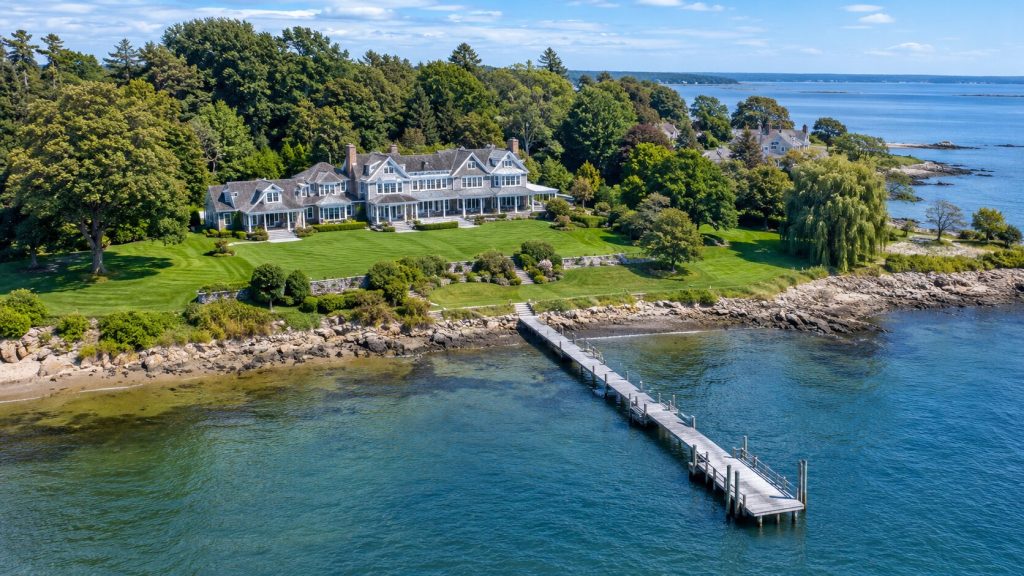
Bigger and more private homes are where a drone really pays for itself. The features that justify the asking price on a high-end listing, a curving estate driveway, the pool, a tennis court, the guest house half-hidden in the trees, barely register from the pavement. You have to get above them.
Waterfront and shoreline properties
Near the Sound, water is usually the whole reason a home commands its price, and it is stubbornly difficult to photograph from ground level. One aerial frame captures the dock, the run of shoreline, and any private beach access at once, showing how close to the water the house really stands.
For a buyer scrolling from Manhattan, that is frequently the single image that makes them clear their Saturday.
Estate and large-lot properties
On a large parcel, drone photography in real estate does for the grounds what a floor plan does for the interior: it lets a buyer grasp the whole thing at once. This is where the benefits of drone photography in real estate are hardest to argue with.
Acreage, established planting, a barn or workshop, the plain fact of privacy, none of it lands from a tight shot at ground level the way it does from the air. Someone paying for space wants to actually see it, and an aerial gives them that in one look.
What to expect when you book a drone shoot
Adding drone coverage is not a second production. It bolts onto the photo or video shoot you were booking anyway, and using drones for real estate this way usually means one visit covers the lot, with the aerials landing in the same gallery as everything else.
The weather is the thing to plan around. Drones stay grounded in high wind or rain, so if the forecast turns, that part of the shoot moves to another day. Every pilot in this game deals with it, and it is no reason to be wary. What you should check is the paperwork.
Anyone flying commercially needs FAA Part 107 certification and proper insurance, so ask before you book. At Home Media is a Westchester and Fairfield County real estate media company, and its pilots hold that certification as a matter of course.
Three signs your listing needs drone coverage:
- The lot is large, over roughly half an acre, or the grounds are a selling point in their own right.
- The property is waterfront or near a recognizable landmark such as a park, golf course, or the shoreline.
- It’s a luxury or above-median listing where buyers expect premium marketing.
If you want to build a full aerial and twilight package, pair this with twilight real estate photography to capture shots of the home glowing at dusk. It’s also worth reading our broader real estate photography tips to get the most out of a shoot.
Bottom Line
The benefits of drone photography in real estate are quite simple. A buyer gets to see the land and how the house sits in it, which is the one thing a ground-level photo can never quite manage.
On the right property that can be what tips a passing scroller into a booked viewing, and the benefits of drone photography in real estate are never more obvious than on a large, waterfront, or luxury home.
Your next listing deserves better than a photo from the pavement. See what our drone services can do for it.
Frequently Asked Questions
Do I need drone photos for every listing?
No. Drone photos for real estate are most valuable on larger lots, waterfront homes, and luxury or above-median listings where the setting is a genuine selling point. A modest condo on a small lot usually gains little from them, so let the property decide.
Is drone photography legal everywhere?
Commercial drone flights in the U.S. require FAA Part 107 certification, which all professional operators must hold. Some municipalities and HOAs add their own restrictions, so confirm local rules for any specific address before shooting.
What happens if it's too windy or rainy to fly?
Drones can’t operate safely in high wind or heavy rain, so the aerial portion is simply rescheduled for the next suitable window. The rest of your shoot can usually go ahead as planned.
How much does adding drone coverage cost?
It’s typically a modest add-on to a standard photo or video package rather than a separate expense. For current pricing on your specific listing, ask when you book, since it depends on the property and the rest of the shoot.

No Comments